- Dr. A.K.M. Saiful Islam, Associate Professor, IWFM, BUET, Dhaka-1000, Email: akmsaifulislam@iwfm.buet.ac.bd
- Prediction of temperature (0C) and rainfall (mm/day) over Bangladesh using SRES A1B scenarios
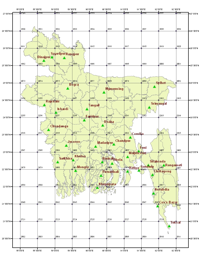
Regional climate model PRECIS has been used to predict various climatic parameters such as temperature and rainfall over Bangladesh. The mean temperature and rainfall have been calculated from the data collected by ground based stations of Bangladesh Meteorological Department (BMD) during 1948-2007. The following maps show various measurement stations in Bangladesh and PRECIS 50km grid with 0.44 degree resolution.
Click on any station to see the mean values (1948-2007) and future predictions (1990-2090) of temp. and rainfall
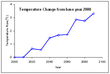
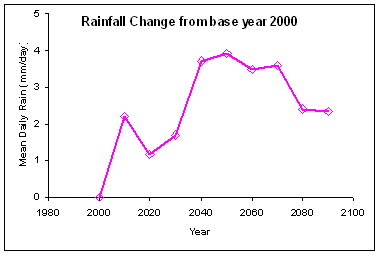
- Change of mean temperature and rainfall over Bangladesh
The mean daily temperature and rainfall over Bangladesh have been predicted by PRECIS regional climate modeling. Results of mean changes (deviation) from base climatic year (2000) are presented in the following two graphs.
 |
 |
|
|
- About regional climate model - PRECIS
PRECIS (pronounced as in the French précis - "PRAY-sea") is based on the Hadley Centre's regional climate modelling system. A regional climate model (RCM) is a downscaling tool that adds fine scale (high resolution) information to the large-scale projections of a global general circulation model (GCM). GCMs are typically run with horizontal scales of 300km; regional models can resolve features down to 50km or less. This makes for a more accurate representation of many surface features, such as complex mountain topographies and coastlines. It also allows small islands and peninsulae to be represented realistically, where in a global model their size (relative to the model gridbox) would mean their climate would be that of the surrounding ocean. RCMs are full climate models, and as such are physically based. They represent most if not all of the processes, interactions and feedbacks between climate system components represented in GCMs. They produce a comprehensive set of output data over the model domain. There are three types of technique for obtaining regional climate change projections: statistical, dynamical and hybrid (statistical-dynamical) techniques. RCMs fall into the dynamical category.
** source: http://precis.metoffice.com/new_user.html#WhyReg
-
PRECIS experiments over Bangladesh 50km grid (0.44 degree)
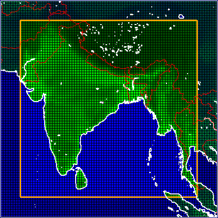
The following figure shows schematization of PRECIS experiment over Bangladesh. The position of pointer has longitude of 143.04 and -10.06 (rotated longitude 59.06 and rotated latitude -24.15) . The grid resolution is 0.44 degree having a domain of 88 by 88 with longitude of TLC is 336 and latitude of TLC is 15.9. Coordinates of rotated pole has longitude 270.27 and latitude 66.09.
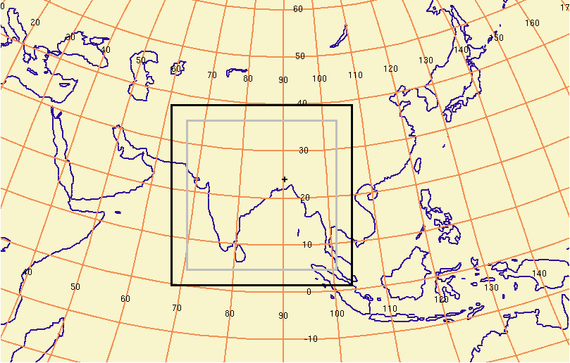
Figure below shows domain of the simulation (region) over Bangladesh.
 |
 |
|
a. Domain of simulation consists of 88 rows and 88 columns for 50km grid. A rim of 8 pixels along the boundary will be excluded from the analysis. |
b. Zoom window over Bangladesh for 50km grid. Land mass is shown by green pixels and ocean is shown by blue pixels. |
- SRES A1B Scenarios
Special Report on Emissions Scenarios (SRES) A1B scenario assumes a balanced mix of technologies and supply sources, with technology improvements and resource assumptions such that no single source of energy is overly dominant. The implications of these alternative development paths for future GHG emissions are challenging: the emissions vary from the carbon-intensive to decarbonization paths by at least as much as the variation of all the other driving forces across the other SRES scenarios.
Last Updated on June 10, 2009. Contact: Dr. A.K.M. Saiful Islam, Associate Professor, IWFM, BUET, Dhaka-1000, Bangladesh. Email: akmsaifulislam@iwfm.buet.ac.bd